This week, we return to one of my favorite things: architectural jargon!
While you may think of it as useless architectural history, I promise you that it will come in handy someday during a trivia Tuesday.
Trust me.
Someday, someone will be impressed with your knowledge of oriel windows.
So, what are they exactly? My handy-dandy Guide to Vermont Architecture uses the following definition:
“Multi-sided window that projects from the wall of a building, and whose base does not reach the ground.”
If the window starts on the first floor then you can call it a “bay” window; bay windows can be more than one story in height much like oriel windows.
Another definition comes from Thought Co.:
“An oriel window is a set of windows, arranged together in a bay, that protrudes from the face of a building on an upper floor and is braced underneath by a bracket or corbel.”
Here’s a definition of oriel windows from John Britton’s, A Dictionary of the Architecture and Archaeology of the Middle Ages: Including Words Used by Ancient and Modern Authors in Treating of Architectural and other Antiquities: With Etymology, Definition, Description, and Historical Elucidation: Also, Biographical Notices of Ancient Architects, which was printed in 1838:
So, where’d the idea of these windows come from you’re probably wondering!
Well, oriel windows most likely originated in the Middle Ages, not just in Europe but also in the Middles East.
In Europe, it may have developed from the word for porch or gallery, “oriolum,” which is medieval Latin. As you can see there’s a connection between the words, “oriel” and “oriolum.” Merriam Webster’s dictionary points to the first known usage of the word in the 14th century while the Encyclopedia Britannica says “oriel” became “prevalent” in the 15th century and were often placed over gateways or entrances to manor houses and public buildings.
So why would you want an oriel window- besides using it to spy on who’s coming to the manor for dinner tonight? It also allowed more light into a room and expanded the flood plan. The window style also offered a way for air ventilation and keeping a room cooler, which would have been ideal in the Middle East. In the Middle East, this style of window first appeared in 12th century Baghdad during the Abbasid Period. The window was called, mashrabiya, and were known for their ornamental lattice screens. In the Middle Eastern architecture, they were typically found on the side of the buildings and/or on the courtyard side of a house. Through the ages, the mashrabiya often would be designed based on the current architectural styles of the time, for example during the 1920’s and 1930’s, the mashrabiya lattice work was inspired by the Art Noveau and Art Deco styles.
Here in the United States, oriel windows can be found on a variety of buildings with different architectural styles, such as: Tudor Revival, Gothic Revival, and Queen Anne.
In another exciting book found on Google Books, here’s instructions on how you would have constructed an oriel window in the 1840’s as detailed by Alfred Bartholomew in Specifications for Practical Architecture, Preceded by an Essay on the Decline of Excellence in the Structure and in the Science of Modern English Buildings; With the Proposal of Remedies for those Defects:
*I am not making up these titles of these books that I found on Google Books*
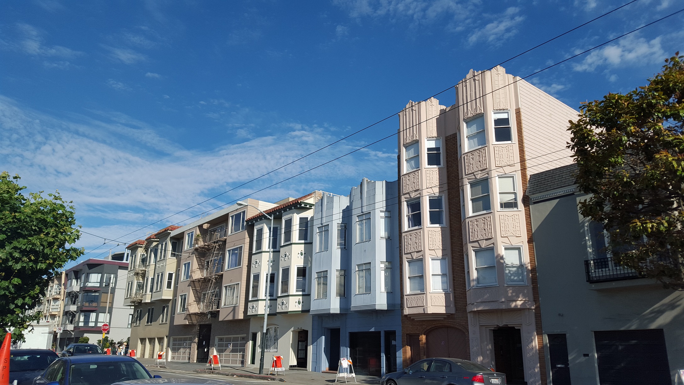
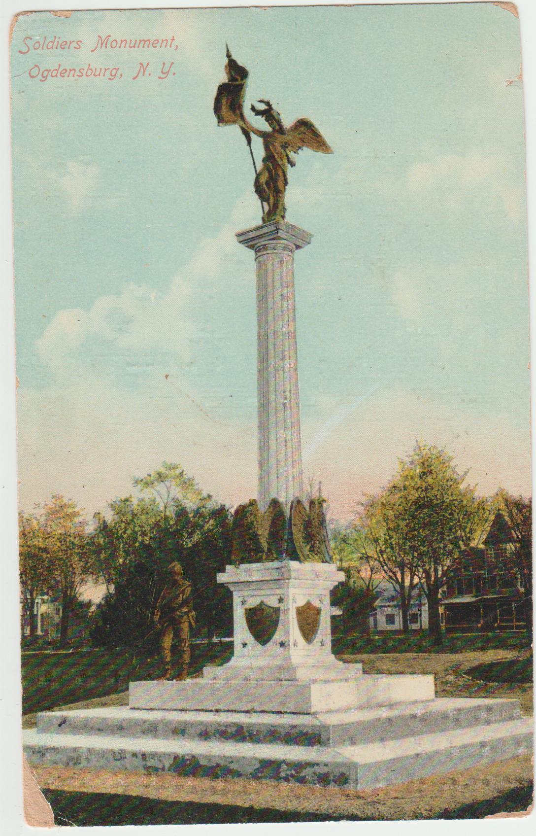
This is the Arlington. It was originally a hotel in downtown Potsdam, NY. It’s now a mixed-use building with businesses on the first floor and apartments on the second and third floors. In addition to that awesome information, it has a wonderful oriel window that extends two floors.Close-up view of the Arlington’s oriel window.Oriel windows seen in San Francisco’s Chinatown.These triple-decker oriel windows can be found in San Francisco. Where exactly you’re probably wondering…I have no idea, I think they’re somewhere near the Palace of Fine Arts.A collection of oriel windows with major Art Deco vibes. These are somewhere in San Francisco……no idea where though. Sadly, when I’m walking around cities taking photos of fun buildings I’m not always documenting the exact location.This oriel window is also in San Francisco. The place is just filled of oriel windows. Good news is I know where this is located: 100 Carl St, San Francisco, CA 94117 (about a block away from the south-east corner of the Golden Gate Park).Plot twist, this isn’t an oriel window but a bay window! This house is located in Ogdensburg, NY (located next to the Post Office). Please, someone buy it and make it look beautiful again.
(Let’s talk about Google Books. They’re amazing. You can read previews of many newer books but can also find the full text for many older books and periodicals, which can be fantastic when researching quirky architectural history topics.)
Curtis B. Johnson, editor and Elsa Gilbertson, Principal Author, The Historical Architecture of Vermont: Guide to Vermont Architecture (The Vermont Division for Historic Preservation, 1996) 27.
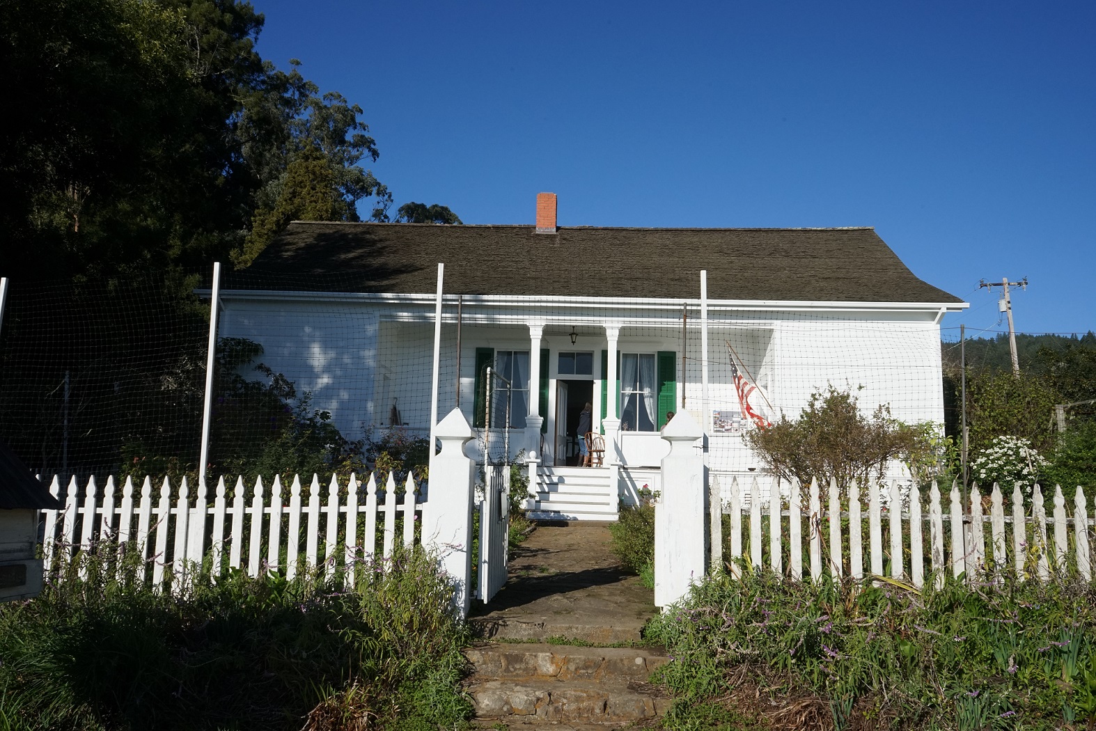
Today we’re looking at the Ogdensburg Public Library located at 313 Washington Street in the downtown historic section of the Ogdensburg, New York. Behind the library is a green open space called Library Park, which is the home to the Spirit of Liberty monument that was installed in 1905.
The Ogdensburg Library as an organization dates back to 1828 and throughout the years moved around the city and never had a permanent home. That was the case until the 1890’s, through the efforts of Dr. Fred Van Dusen, the Ogdensburg Public Library saw some significant changes that would have lasting effects to the library’s establishment in the city. Changes included getting the library officially incorporated by the State Board of Regents in 1891 and eventually getting a permanent home for the library: the Clark House at 311 Washington Street.
The Clark House was a private residence built in 1888 for George C. Clark, a New York banker, who has used the house as a summer residence for his family. Prior to construction of the new Clark summer home, the property was originally the location of the Greek Revival home of Joseph Rosseel (also spelled Roselle) stood. Rosseel had been the land agent to David Parish one of the early landowners in St. Lawrence County. Rosseel employed Joseph Jacques Ramee to design his Greek Revival home in 1810. When Clark purchased the property, he had the old house demolished to build his Queen Anne home. By 1895, Clark was beginning to have second thoughts. Given the distance from Ogdensburg to New York City, Clark determined it would be better to have a summer residence closer to the city. Clark offered his home and entire block for the new home of the library for $35,000 ($10,000 of which Clark donated). The home was estimated to be worth $125,000. In addition, Clark gave his dock property (land between his residence and the streets) to be used as a park space in the city- this is today’s Riverside Park in Ogdensburg.
A side note about the Clark House, different sources say slightly different things about the house. One article reporting on the fire dated November 25, 1921 (Ogdensburg Republican Journal) said that Clark, “greatly overhauled and renovated,” the original 1812 structure for his summer residence. While other sources say that Clark completely demolished the older building to construct a completely new home. It’s unclear why there is a discrepancy in the information on what exactly happened but it would be safe to say that if any portion of the library is the original 1812 building still exists it would be difficult to determine given the level of renovations through the years and the 1921 fire.
In early 1921, funding was given from the estate of George Hall and John C. Howard to be used to complete needed renovations of the library’s main building and the library’s annex- George Hall’s house across the street. John West was hired as the contractor for the renovations, which were coming along fine and would have been completed by February of 1922 but a fire broke out on November 24, 1921 destroying most of the interior of the library.
Luckily, all of the collections were safe. The books, records, Frederick Remington paintings, and original bronzes had been placed at either the George Hall residence or in a massive safe in the library’s basement.
George Hall’s residence happened to be the former residence of Frederick Remington. The home is literally across the street from the library and today houses the Frederick Remington Museum. The museum does have a permanent exhibit on Sally James Farnham, more about her below.
The fire was discovered around 7 am by a passerby on the way to the local market. The fire department was alerted immediately and the local firefighters in their response to the blaze, were assisted by sailors from the USS Chillicothe, which was moored at Riverside Park. They weren’t’ successful in putting the fire completely out until noon of that day.
John Wert originally estimated the damages could be anywhere between $25,000-$50,000, and the entire building was gutted. A few weeks later, the damages were able to be assessed and the losses only totaled $15,000, which was covered by insurance. The cause of the fire was determined to be an overheated hot air furnace. The flooring and the roof completely burned but the walls somehow remained in good shape, allowing reconstruction to still be possible. The reconstruction work that occurred resulted in the library that we see today- it was rebuilt as a replica of the old 1812 Rossell Mansion.
It is a Pokemon Gym for all those planning on Pokemon Going your way across Northern New York.
Front facade of the Ogdensburg Public Library
A view of the backside of the library while standing in Library Park.
Library Park:
Associated with the public library is Library Park, which is home to the Spirit of Liberty, a sculpture by local Sally James Farnham. The Park is behind the library and was laid out in 1903- the area was also part of the Clark Property.
When the library acquired the Clark Mansion in 1895, it also acquired a fantastic open space that was planned out to be a park for the city. Plans were eventually created in 1903 and not finally completed until the following year. The plans for the landscaping of the Library Park as it was called, were drafted by Arnold E. Smith and Dr. Dusen assisted in getting the authorization to complete the layout around the library.
The Commercial Advertiser on July 5, 1904 reported that the park plans consisted of, “a horse-shoe or semi-circle of, prominent, outlining, the concave facing the river, the library building at the apex, forming the background. The fountain, as now located, the central figure; the proposed soldier’s monument about one hundred feet westerly there- from and a little lower down…” In addition to this description, the park was to have trees throughout the park such as cherry, Persian lilac, and hydrangea and principal walkways were to be laid out from corner to corner of the park, crossing at the center in front of the fountain.
An aerial view of Library Park via Google Maps. It gives a good overview of the layout of the Park.
The photographs above show what the walkways look like at the Park as well as the Spirit of Library at the Park.
In the same year that finishing touches were made to Library Park, Sally James Farnahm, won her first commission via competition- a Union soldier monument to be placed in the park. Sally had submitted to models to the monument committee of Ransom Post, GAR, “Defenders of the Flag” and the “Spirit of Liberty.” Funding for the monument came from a number of sources: Mr. and Mrs. George Hall, Swe-Kat-Si Chapter GAR, Fortieth Separate Company, Ransom Post GAR, Post Card Subscriptions, and even from Sally Farnham herself.
The Spirit of Liberty:
The Spirit of Liberty was installed at the Park in 1905. The city of Ogdensburg had held a competition for a Civil Ware monument for the Park for the soldiers and sailors from the town of Oswegatchie who died during the Civil War. Sally James Farnham submitted two different designs: Defenders of the Flag and the Spirit of Liberty. Out of 15 submissions, Sally’s Spirt of Liberty was chosen by the City.
Based on the postmark date of 1909, this shows a pretty accurate view of the Spirit of Liberty after its installation. You’ll notice the statue of the solider at the base. It is no longer a park of the monument due to vandalism and is currently in storage from what I heard.
Sally was born in 1869. Her mother passed away when she was 10 years old, for this reason Sally was very close to her father and they traveled around the world. While Sally wasn’t formally educated in an art medium, she was exposed to art throughout her travels with her father to France, Norway, Scotland, and even Japan. In 1896, Sally married George Paulding Farnham, who was the design director for jewelry and silver at Tiffany & Co. Yes, THE Tiffany & Co.
Sally’s first experience working with modeling clay was the result of both a personal tragedy- the death of her father- and a serious illness that left her bedridden. Her husband, George, during this time brought home clay for her to work with, hoping it would help improve her spirits. Sally greatly became interested in working with clay as an art medium- she was guided partly by her husband, who was a member of the National Sculpture Society, and more importantly by Frederick Remington, who was another native of Ogdensburg and a family friend of Sally’s. Remington supported and encouraged Sally’s artwork up until his death in 1909. Oddly enough Remington lived in the house across the street from the building that is the city’s public library. It’s fitting that Sally’s sculpture not only stands high in her hometown but also in view of her friend and mentor’s old house. The other unique thing about Sally James Farnham is that she was one of the first women to successfully compete for national sculpture commissions, like the one for the Ogdensburg Civil War monument.
In competing for the Ogdensburg Commission, Sally had a strong connection to wanting to design the city’s Civil War monument, not only was she obviously a local to the city but her father was Col. Edward C. James who commanded the 106th NY Volunteers during the war. Her winning design features a winged Victory with laurel wreath and flag atop of a 35-foot granite column and pedestal (the granite is from the quarries of Barre, Vermont). The pedestal features four bronze war eagles and shields. Originally, the base also had a life-sized bronze soldier, it has since been removed due to damages caused by vandalism. The monument was officially dedicated on August 23, 1905 and was attended by almost 20,000 people including the USA Vice President, Charles Fairbanks. Later in her career, Sally created a similar Civil War monument for Bloomfield, New Jersey, which was dedicated on June 11, 1912- in 2001 the monument was restored by the city.
The above views are what the Spirit of Liberty currently looks like at Library Park.
Some of Sally’s other sculptures include: The Defenders of the Flag (1908), which is a Civil War monument located in the Mt. Hope Cemetery in Rochester, NY; the Frieze of Discovers (1910) located in the Pan American Union (now OAS) building in Washington D.C.; and the Simon Bolivar statue (1921), which is located in Central Park in New York City.
The Public Library, Library Park, and the Spirit of Liberty make up a portion of the Library Park Historic District in Ogdensburg. Other contributing properties include the Remington Museum and other houses along the square block made by Washington, etc. All of these sites are easily accessible in the historic downtown area of Ogdensburg, NY. The park is also in close proximity to the riverside where there is a walking trail that leads to the Maple City Trail and the Abbe Picquet Trail on Lighthouse Point!
Thanks for reading !
Resources and Further Information
Online Resources:
John C. Howard, “A History of the Ogdensburg Public Library and Remington Art Memorial,” Ogdensburg Journal, May 31, 1938. The Trustees of the Ogdensburg Public Library.
John Harwood, National Register of Historic Places Inventory- Nomination Form, Library Park Historic District, Sept. 1982.
This was an unexpected blog post but a few days ago was the 150th anniversary of the completion of the Transcontinental Railroad. The Transcontinental Railroad was officially completed at Promontory Point, Utah on May 10, 1869 and it connected the county by rail.
A number of years ago, when I was still working part-time at the Potsdam Public Museum, I created a very simple mini-exhibit on the Transcontinental Railroad. The exhibit showed via railroad maps how, with the completion of the Transcontinental Railroad, it was possible to get from Potsdam, NY to the West. The mini-exhibit was super mini and I don’t think that many people got to see but hey, this is a different platform and I’m sure someone will be interested in cross-country travel in 1869.
Along those lines, last weekend, I attended a cool tour at the Old City Cemetery in Sacramento, which gave a walking tour related to the Transcontinental Railroad. While few of the key players are actually buried in Sacramento there are a lot of connections to the city.
During the tour, I learned about some of the well-known names involved in the creation of the Transcontinental Railroad. For example, Theodore Judah, who was the brains and architect of the TC railroad; the idea was to get a railroad through and over the Sierra Nevada. He was originally born in Connecticut but lived in Troy, NY with his family for a number of years. On May 10, 1847 he married Anne Pierce. Sadly, though he died before construction began though but not before giving his wife enough information to make sure financing was secured for the railroad. Two of the volunteers with the cemetery acted the parts of Theodore and Anne. They did a pretty good job and the most interesting parts were about Anna to be honest. She apparently did a number of sketches while traveling to California. In additional the other interesting tidbit about them was that the completion of the railroad occurred on what would have been their 22nd wedding anniversary if Theodore hadn’t passed away. Neither are buried in Sacramento but instead in Greenfield, Massachusetts.
Another group of people connected to the railroad, were the Big Four. They were all business, philanthropists, and railroad tycoons who pooled their resources to create the Central Pacific Railroad, which would be the western portion of the Transcontinental Railroad. In addition they became even more wealthy from their involvement in the railroad and there was a lot of shady business that happened. The Big Four were:
Leland Stanford, born in Watervliet (now Colonie), NY. He was originally a lawyer but moved into business before moving to California.
Collins Potter Huntington, originally from Connecticut but settled first in Oneonta, NY where he established a successful business before moving to Sacramento, CA
Mark Hopkins, originally from Henderson, NY (located in Jefferson County). He is buried in the Sacramento Historic Cemetery.
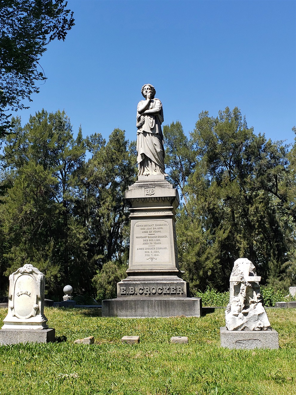
Charles Crocker, he was originally from Troy, NY. He’s part of the same Crocker Family that established the Crocker Art Museum in Sacramento.
As you can see, there’s also a lot of connections to New York, which is super interesting! I have also realized, while on the cemetery tour I didn’t take any photos of any of the stopping points on the tour except from the Crocker Family Plot. Charles Crocker isn’t buried here but his brother, Edwin, is buried here. Edwin was also involved in the Central Pacific Railroad and served as the businesses’ legal council.
The following images are all from maps that are available online and there is bibliographic information for each as well as the website to view the map in whole; all links are still active. The maps show the journey westward leaving from Potsdam, NY and arriving in California via multiple railroad lines across the United States. The portions of the following maps come from larger maps created around 1869, when the transcontinental railroad was completed at Promontory Point, Utah on May 10, 1869. Sadly, when I moved to Sacramento, CA from Brasher Falls, NY I did not travel by train. I took a plane from Massena, NY to Boston, MA, where I switched airlines and then flew non-stop to Sacramento, CA.
This map shows the route from Potsdam, NY to Rome, NY via the Rome, Watertown & Ogdensburg Railroad. This would have been a potential route to get to the West once the transcontinental railroad was completed on May 10, 1869. This map is part of a larger map the, “N.Y. & Oswego Midland R.R. Map,” by Van R. Richmond, State Engineer & Surveyor. January 1st, 1869. That map can be accessed from the Library of Congress’s website: http://www.loc.gov/item/98688733/#about-this-item
This is a portion of the map of the Erie Railway and its connections. The map was created in 1869 and published by G.W. & C. B. Colton & Co. From Rome, a person could head to Syracuse via the New York Central Railroad and then take the Syracuse, Birmingham & NYC Railroad to Birmingham, NY. From Birmingham one could take the Erie Railway headed West. The map in its entirety can be viewed at the Library of Congress’s website: http://www.loc.gov/item/98688655/.
The Erie Railway moves across the southern portion of New York State and into Pennsylvania. The Erie Railway becomes known as the Atlantic and Great Western Railroad moving west towards Lake Ontario in this map. That line then heads south-west towards Ohio. The map in its entirety can be viewed at the Library of Congress’s website: http://www.loc.gov/item/98688655/.
Traveling to the West would potentially involve going through Pennsylvania and Ohio. This portion of the Erie Railway and its connections map shows the Atlantic and Great Western Railroad running south-west through those two states. In Mansfield, OH, one would have changed lines to head towards Chicago. The map in its entirety can be viewed at the Library of Congress’s website: http://www.loc.gov/item/98688655/.
Leaving from Mansfield, OH you would take the Pittsburgh, F. Wayne & Chicago Railroad line. This line heads west through to Crawford, Wyandot, and Lima, the line then travels north-west from Lima, OH towards Fort Wayne. The Pittsburgh, F. Wayne, & Chicago Railroad line would take you all the way to Chicago in Illinois. This is a view from the Erie Railway and its connections map. The map in its entirety can be viewed at the Library of Congress’s website: http://www.loc.gov/item/98688655/.
This map shows the route from Lima, OH (in the bottom right hand corner) via the Pittsburgh, F. Wayne, and Chicago to Chicago, Illinois (in the top left-hand corner). The route goes through three states: Ohio, Indiana, and Illinois. This is a view from the Erie Railway and its connections map. The map in its entirety can be viewed at the Library of Congress’s website: http://www.loc.gov/item/98688655/.
In this section of the Chicago and Southwestern Railway map from 1869, the route from Chicago to the West is highlighted in blue. The railroad you would be one going West at this point is the Chicago & Rock Island & Pacific Railroad. The Chicago and Southwestern Railway map can be viewed in its entirety at the Library of Congress’s website: http://www.loc.gov/item/98688623/.
The blue line is still the Chicago & Rock Island & Pacific Railroad. The goal is to get to Council Bluffs, Iowa, which is where the Union Pacific Railroad starts. That is the line that heads west and meets with Central Pacific Railroad from Sacramento, California. The Chicago and Southwestern Railway map can be viewed in its entirety at the Library of Congress’s website: http://www.loc.gov/item/98688623/.
This shows the Chicago & Rock Island & Pacific Railroad going through Des Moines to Council Bluffs through Iowa. In Council Bluffs, one would change railroad lines and get onto the Union Pacific line headed West. The Chicago and Southwestern Railway map can be viewed in its entirety at the Library of Congress’s website: http://www.loc.gov/item/98688623/.
This is a section from the Central Pacific Railroad Timetable which was created July 9, 1871. Though it was created after 1869, when the Golden Spike Ceremony occurred and the transcontinental railway was completed, it still shows the route one would have traveled in 1869. This portion of the map shows the railway leaving Council Bluffs, next to Omaha and headed West through Nebraska. The rest of this map can be viewed in its entirety at the Central Pacific Railroad Photographic History Museum’s website: http://cprr.org/Museum/Maps/_cprr_map.html.
This portion of the Central Pacific Railroad map from 1871 shows the continued path of the transcontinental railroad. Promontory Point is where the Central Pacific and Union Pacific Railroads connected on May 10, 1869. Promontory Point is located in Utah on the Great Salt Lake. The red arrow points to Promontory Point. From here headed West the railroad line becomes the Central Pacific. The rest of this map can be viewed in its entirety at the Central Pacific Railroad Photographic History Museum’s website: http://cprr.org/Museum/Maps/_cprr_map.html.
This is the last leg of the journey from Promontory Point to Sacramento, California! The route all the way from Potsdam was a long one but worth it in 1869. Going from Potsdam, NY to California, one would have traveled through 11 states and over 2,500 miles and seen a lot of amazing things along the way. The rest of this map can be viewed in its entirety at the Central Pacific Railroad Photographic History Museum’s website: http://cprr.org/Museum/Maps/_cprr_map.html.
National Register of Historic Places In Northern NY
Lisbon Railroad Depot; Lisbon Depot Museum
New York Central Railroad Adirondack Division Historic District
Library of Congress
Map of the Chicago and Southwestern Railway and the Chicago, Rock Island & Pacific Railroad and their Connections. G.W. & C. Colton & Co. 1869. http://www.loc.gov/item/98688623/
Map showing the location of the N.Y. & Oswego Midland R.R. with existing and proposed connection, Jnaury 1st 1869 (by Van R. Richmond, State Engr. & Surv.). 1869. http://www.loc.gov/item/98688733/
Welcome to Adventure with Courtney. We’ll continue to adventure around and see more historically, dorky stuff in 2019. Hopefully, it’s enough to ensure we know way too much about architecture and history to make us all THE person to have on the local trivia team.
I’ve spent the first couple of months 2019 not posting anything. Surprising, I know. If you closely follow this blog, you’ll know that posts were few and far between in 2018 and have probably assumed that 2019 will be similar. There was a lot going on for me in 2018- a new job, moving from Northern New York to Sacramento, CA, and figuring out how to adjust to a new location that’s totally different than NNY. During that time, I didn’t necessarily quite adventuring, I actually saw a lot of cool, historic places: Solvang, tons of things in San Francisco, San Luis Obispo, downtown adventures in Sacramento, Disneyland, etc. you get the point. I saw things, I just sadly didn’t have as much time as I wish I had to share all of those awesome places and little know history on this blog.
So, for roughly the past few months, I’ve been pulling together notes, researching, and planning posts. In doing so, I’ve realized that I have one too many notebooks. It’s a problem that many of us have yet just won’t admit. The exciting news, other than having too many notebooks, is that I think I have pulled together, (I hope) is a good enough starting point to ensure there are enough new Adventures with Courtney to share.
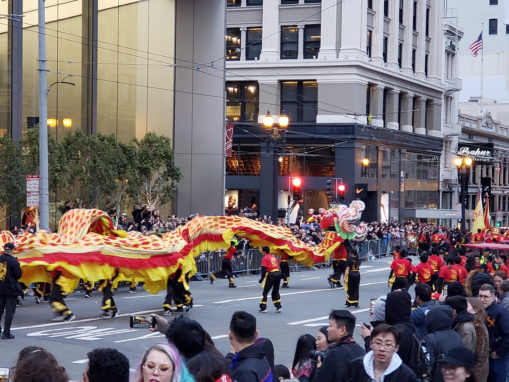
Starting the belated new year on Adventure with Courtney – not just the literal new year of 2019 but also the third year of this blog being a thing- Happy Belated Birthday to this Blog which celebrated its third year on April 1, 2019!- we’ll explore/adventure to one of my favorite cities: San Francisco. I was last in the city near the end of of February to hang out in Chinatown during the Chinese New Year Festival and to see the New Year Parade. It was a lot of fun!
The festival occurred on both Saturday and Sunday along Grant Street in Chinatown, with other festival things happening throughout the neighborhood but I only attended the festival on Saturday. That happened to be the same day as the New Year Parade.
This was the year of the Earth Pig (previous years of the pig include: 2007, 1995, 1983, 1971, 1956, 1947, 1935). People born in the year of the Pig think logically and are good at fixing whatever problem they’re in. I was actually born in one of the years of the snake. In planning my trip to Chinatown and San Francisco, I figured I would do some research to turn the adventure into a blog post. So, I did some research before my trip to find some cool places to check out while in Chinatown other than the festival and a parade and to learn more about the history of San Francisco’s Chinatown, which is the biggest Chinatown in the US.
A Very Brief History of San Francisco’s Chinatown:
A very brief history of Chinatown goes something like this….
The first Chinese immigrants that arrived in San Francisco were on February 2, 1848. They included two Chinese male servants and a Chinese maid, named Maria Seise. They were all brought to San Francisco by an American merchant, Charles Van Gillespie and his wife, Sarah Catherine. The two male servants have been lost to history because they went to work in the gold rush for Gillespie but Marie stayed with the family for 30 years. (Information from that book).[i] From there other Chinese immigrants settled along Sacramento Street and spread to Dupont Street (now Grant Street) in the mid-1800’s. The area slowly expanded from 6-8 blocks in 1876 to more than 12 blocks by 1885. It should also be noted that Chinatown’s location in San Francisco today was, in the early years of the city, the center of mainstream San Francisco…. being the center of the city also resulted in it being a location for gambling, prostitution, and all other things that might be frowned upon in a city. Even though the city expanded quite extensively, the questionable businesses remained in Chinatown giving the community not always a great name.
Chinese immigration also increased because of the need for laborers during the Gold Rush and the construction of the transcontinental railroad. Chinese immigrants to America faced many hardships that basically stemmed from racism. There’s no nice way to put it but that’s what it was. Periods of economic hardships in the USA resulted in unfair and unjust laws prohibiting and/or limiting Chinese immigrants; those that were here already had problems becoming US citizens as well. In addition, laws even limited opportunities of those Chinese immigrants already here in America, for example there was one law passed in San Francisco that specifically targeted laundry businesses of Chinatown. The biggest law of concern was the Chinese Exclusion Act, which was passed first in 1882 and then again in 1930, which prohibited the immigration of Chinese laborers. On paper, the law exempted Chinese merchants and their families, teachers, diplomats, students, and travelers but in reality, the law gave authorities the ability to stop all Chinese immigrants. The law wasn’t repealed until 1943 (the Chinese Exclusion Repeal Act), which also allowed Chinese aliens naturalization rights.
During that time and even beyond 1943, the Chinese of San Francisco’s Chinatown worked hard to change the public’s bias and perception of the Chinese. The first opportunities arose from the Great 1906 Earthquake. The earthquake basically destroyed much of Chinatown, which happened to be the older section of the city to begin with. The destruction allowed the rebuilding of Chinatown to take not only an interesting turn but ultimately into the hands of the local Chinese population. Look Tin Eli, the secretary of the Chinese Chamber of Commerce and other Chinese merchants such as Tong Bong and Lew Hing, saw this as an opportunity to rebuilding Chinatown into a “tourist mecca” that could help improve the image of Chinatown and relationship with the San Francisco community.[ii]
Some of the first buildings in Chinatown after the earthquake included Sing Fat Building on the southwest corner of Grant Street and the Sing Chong Building across the street on the northwest corner. The new buildings were eclectic combining Western European building elements, like columns, brackets, cornices, etc. with Oriental rooflines. (Images) Basically, the Chinatown you see today all stems from what was created after the 1906 Earthquake. Throughout this entire time the Chinese brought with them to the USA their heritage and celebrated extensively their culture through events like New Year’s. The first modern Chinese New Year parade in San Francisco occurred in the early 1950’s. The book, Making an American Festival goes into the fascinating history of the New Year festival and parade and how it was in response to Chinese-American leaders of San Francisco’s Chinatown to the political and economic difficulties of the Cold War. One of the interesting quotes from early in the book is as follows, “Chinese immigrants brought old world traditions and rituals- including Chinese New Year celebrations- to the host country. These old world rituals served as a link between immigrants and their home countries and created a sense of community in their adopted country.”[iii] The Chinese Chamber of Commerce was the main push behind the festival and parade. Henry Kwock Wong, a local businessman, and others such as, John Kan, and Paul Louie, saw the festival and parade as a way to change the public image of Chinese Americans and the celebration as an important manifestation of American freedom, “because China had fallen into Communist hands, it was American freedom that preserved Chinese traditions.”[iv]
Basically, the idea was that San Francisco’s Chinatown was “real” tradition China because of the communism in China and again Chinatown’s’ leaders accentuated Chinatown as an exotic and foreign place. “Organizers designed activities that catered to tourists’ orientalist expectations- in other words, their ideas of Chinese American cultures as exotic and different.”[v] Quick example, the fortune cookie was invented in the 1930’s in Chinatown to attract tourists. Though not exactly from the 1950’s it helps show that Chinatown has been catering to tourists for a very long time. Since the 1950’s, the New Year’s festival and parade have grown to be a huge event in San Francisco.
Quick Thoughts:
My knowledge of San Francisco’s Chinatown was pretty limited before researching for my recent visit to see the parade and festival. Researching about Chinatown was an eye opener on a period of history I’m not too familiar with to be honest. It was a lot to think of and also wonder if me visiting Chinatown during the Chinese New Year celebrations would just make me seem like one more person perpetuating all of the bad history surrounding San Francisco’s Chinatown. When thinking of visiting Chinatown to see the New Year Parade and Festival, I was planning on going not because I view Chinatown as exotic but because I think going to Chinatown is a great way to learn more about a culture different from my own. I guess my thoughts on going to Chinatown were not any different than if I had been planning on going to any other new city, town, or place for the first time. I guess being from a small town in Northern New York, any large city or community catches my interest because everything is so different from what I’m used to.
At the writing group I go to on Sundays (Shut Up and Write), I briefly discussed with a few of the regulars the blog post I was writing about Chinatown and how researching the New Year’s festival brought up a bunch of other issues related to cultural identity, cultural appropriation, and racism. How do you combine the history of San Francisco’s Chinatown, its New Year festivities, the fact that Chinatown’s community and people have had to worked hard to promote the community as “exotic” to make US people see them as American citizens, and does me visiting as a tourist or anyone else for that matter, continue the conception that Chinatown is exotic and the underlying history of racism? That’s not an easy combination of ideas to pull together, that’s for sure! It was an interesting conversation to have with other people who helped confirm that there’s a lot going on when acknowledging the history of San Francisco’s Chinatown. Though it was helpful to talk with some of my co-writers and get their feedback, I’ve realized that there is no easy way to conclude this or even summarize my thoughts. But I guess as someone who likes history and learning about other cultures, all I can do is emphasize how important it is to do research and learn about other cultures, and don’t be surprised when you learn about really crappy things like the Chinese Exclusion Act. Hopefully, learning about those shitty periods in history make you want to be better and more respectful of the hodge-podge of cultures that make up the United States.
How Did My Visit Go:
Did I do the tourist thing in Chinatown? Yes, I think so. At least, I tried to do the things where I got to learn more about Chinese heritage and history. So, things I did included just walking around Chinatown. There’s a lot to see and take in, especially when there’s so many also walking around and enjoying the festivities!
I also went to the Chinese American Historic Society that had some cool events going on to add to Chinatown’s celebrations! I actually didn’t know their schedule but I arrived in time to see the Lion’s Dance!
The building was originally the Chinatown YWCA designed by Julia Morgan.
The performance started at 11 am and was done by the Kei Lun Martial Arts
One of the lions came into performance area by dancing through the audience.
The museum has a number of exhibits related to different aspects of Chinatown’s History. On the lower level are a number of posters related to women’s history in Chinatown. On the main level is a very comprehensive history of the good, the bad, and the ugly when it comes to Chinatown. There’s also a lot of personal history and stories documented there.
I also went to the Hang Ah Tea Room for lunch. It’s the oldest dim sum restaurant in San Francisco- again, if there’s historic restaurants to hit up, I’m there! The restaurant is located at 1 Pagoda Place; best way to explain that thought is it’s technically in an alley on the backside of buildings located on the corner of Stockton and Sacramento streets. My best advice is to follow the signage to get to the restaurant, which is going to start at the corner of Stockton and Sacramento and point you down Sacramento Street and then point you again into the alley. Google Maps kind of confused me and I wasn’t sure where I was supposed to go until I saw those signs pointing me in the right direction. Trust me, Google Maps will say you’re there but LOL you’re not. Look for the signs!
It is the oldest dim sum restaurant in Chinatown.
Interior when you first walk in.
These were the xiao long bao, also known as the soup dumplings.
These were the ha gow, which are shrimp dumplings. They were very good.
The place, when you find it, will most likely be packed. Being by myself meant it was easy for the servers to seat me. YEA! To Solo Dining. I had no idea where to start on the menu and when my server showed up less than 5 minutes after sitting down, I just asked her what she would suggest to get. Her choices were great and are what I would suggest to you!
Additionally, the following books were not at my local library but I found on Google Books and had a lot of interesting information on Chinese celebrations:
Good Luck Life: The Essential Guide to Chinese American Celebrations and Culture, Rosemary Gong, 2005, Published by HarperCollins.
Mooncakes and Hungry Ghosts: Festivals of China, Carol Stephanchuck and Charles Choy Wong, 1991, Published by China Books and Periodicals, Inc.
This website also has a lot of information on the history of the Chinese in San Francisco. Scroll about half-way down to the page to the find the section on Chinese topics:http://www.sfmuseum.org/hist1/index0.html
The Chinese Historical Society of America:https://chsa.org/exhibits/online-exhibits/ .The website has a lot of information about their current exhibits that include: Chinese American Exclusion/Inclusion and there’s a lot of resources about Chinatown and the Chinese experience.
The books I reference below can be found hopefully at your local library but there are portions that can be previewed at Google Books:
[i] Choy, Philip P., San Francisco Chinatown: A Guide to its History and Architecture, (San Francisco: City Light Books, 2012), 30-31. And information from the San Francisco Chinatown website timeline.
[iii] Yeh, Chiou-ling, Making an American Festival: Chinese New Year in San Francisco’s Chinatown, (Berkeley and Los Angeles: University of California Press, 2008), 15.
It’s been a while since we’ve talked about some architectural jargon, so that’s what we’re doing this morning!
So, balusters…. balustrades…. you’ve seen them, you’ve heard of them but really, what are they? Could you actually define them? Everything you’re about to read, will be on the test later. So pay attention!
A balustrade as defined by my handy-dandy “Guide to Vermont Architecture” says this:
“A row of vertical balusters or other elements topped by a handrail and used to edge stairways, porches, balconies, and roof lines.”[i]
It just so happens that a “baluster,” is one of number of terms that can be used to name a turned or rectangular upright support seen in the balustrade. Other names you may see include: “banister,” “column,’ “spindle,” or even “stair stick.”[iii] Personally, “stair stick” is my new favorite and will be the technical term I use going forth in any official building description I write ever again. That’s a joke, I’m like 90% sure no State Historic Preservation Office would be pleases to see balusters called “stair sticks.” The term, “baluster,” can also be used to described a type of metal candle stick, an upright furniture support, or event the stem of a brass chandelier.[iv]
Balusters and balustrades can be seen in a number of different forms and materials including wood, stone, metal, and plastic. In the history of baluster development, cast-stone balusters were first developed in Great Britain during the 18th century. While cast iron ones didn’t make an appearance until the 1840’s.[v]
The term, “baluster,” didn’t really come into use until the 17th century and originates from the Italian word, balaustro or balaustra, which in turn comes from the Latin word, balaustium. All of these words by the way means, “flower of the wild pomegranate.”[vi] We’ll come back to that interesting word in a moment.
Even though the word “baluster” and “balustrade” wasn’t in use until the 1600’s, the architectural element makes its first appearance in ancient Assyrian sculptural murals, also called “bas-reliefs,” which date all back to the 13th-7th century BC. In the murals, balusters and balustrades can be seen in palaces lining windows. This helps hone in on the function of a balustrade other than potentially being a decorative architectural feature, it helps reduce the possibility of a person falling. While balustrades make an appearance in ancient Assyrian art, we’re not sure exactly if there was a specific word used for the building element. Another interesting thing is that balusters and balustrades do not appear in ancient Greek or Roman ruins or art. The Romans did use a type of lattice structure though, crisscrossed panels called, transennae or clathii that could be constructed of wood, bronze, or even marble.[vii]
Balusters and balustrades as we know them did not reappear in the “modern” era until the Renaissance in Italy- not surprising because of the Italian origin of the word. The first known or maybe surviving first use of the balustrade in architecture is on the Pitti Palace in Florence constructed c. 1448. Another important, early example of the balustrade can be seen on the Drum of the Tempietti, which was designed by Donato Bramanti c. 1502. The Drum is at the Monastery of San Pietro in Montorio, which brings us back to the Italian and Latin root of “baluster.” Both origin words of “baluster” means the “blossoming flower of the pomegranate.” Most likely when you think of a single baluster, you think of a vase shaped mini column, which is actually what the blossoming pomegranate flower looks like! Some more trivia about balusters to impress your friends with include that the narrow section of the vase shape is known as the “sleeve,” while the wide section is called the “belly.” The balusters at the Drum of the Tempietti consist of two vase shapes connected at the “belly” end, which kind of looks like a candlestick and was probably inspired by Roman candlesticks. This type of baluster design is sometimes called the “double” baluster.[viii]
Last little tidbit on balusters and balustrades is that they can be found on staircases or porches, as well as along roof tops or roof lines, in a variety of different architectural styles including: Neoclassical, Colonial Revival, Federal, Georgian Revival, Beaux Arts, and Italian Renaissance Revival.
See below for a bunch of examples of balusters and balustrades I’ve photographed throughout the years!
View of the vase-shaped balusters in their balustrade from the Upper Palace of the Belvedere Museum in Vienna, Austria. The baroque castle was constructed from 1717-1723.
This is an interior view of the Library of Congress in Washington D.C. Specifically we’re looking at the ornately designed Great Hall, which along the upper level has a marble balustrade.
A view of the Main Reading Room in the Library of Congress, which also has a lovely balustrade, which consists of the “double” baluster. The Library of Congress is a Beaux Arts style building constructed from 1890-1897 and the main architect was Paul J. Pelz.
This is the balustrade that can be seen along the roof line of the US Capitol Building. The building was designed by William Thornton in the Neoclassical style and was constructed from 1793-1800.
Interior view of the Crocker Museum, which is located in Sacramento, CA. Looking up in the ballroom and you can see the wooden balustrade up above. The Crocker House was redesigned in the Italianate Style by local architect, Seth Babson and was officially completed in 1872.
A view of the balusters and balustrade on the front porch of the Frederic Remington Museum located in Ogdensburg, NY. The house was originally constructed in 1810 for David Parish, an early resident.
A view of the front facade of Hearst Castle, which is located near San Simeon, CA. The castle was designed by Julia Morgan in the Mediterranean Revival style for William Randolph Hearst. The structure was worked and from 1919 to 1947. The balusters and balustrade visible on the upper level are in association with window and balcony openings and are most likely constructed of metal.
Vesuvio Cafe in San Francisco features a balustrade with “double” balusters along the mini balcony created by the set of french windows on the second floor. The building was designed in 1916 by Italian architect, Italo Zanolini.
Add a comment if you have any questions or thoughts about balusters and balustrades!
Thanks for reading!
End Notes:
[i] Curtis B. Johnson, editor and Elsa Gilbertson, Principal Author, The Historical Architecture of Vermont: Guide to Vermont Architecture (The Vermont Division for Historic Preservation, 1996) 24.
This post has been in the making for at least the past month or at least once I learned that Azure Mountain’s Fire Tower celebrated its centennial on July 29, 2018. This post is a little more personal than usual because I grew up hiking Azure Mountain yearly and also because the fire tower on Azure was constructed with the intent of being part of the fire detection network New York State created in the early 20th century. It oddly has some relevance given the fact that the state of California, where I currently reside, has had a hard recently with wildfires throughout the state.
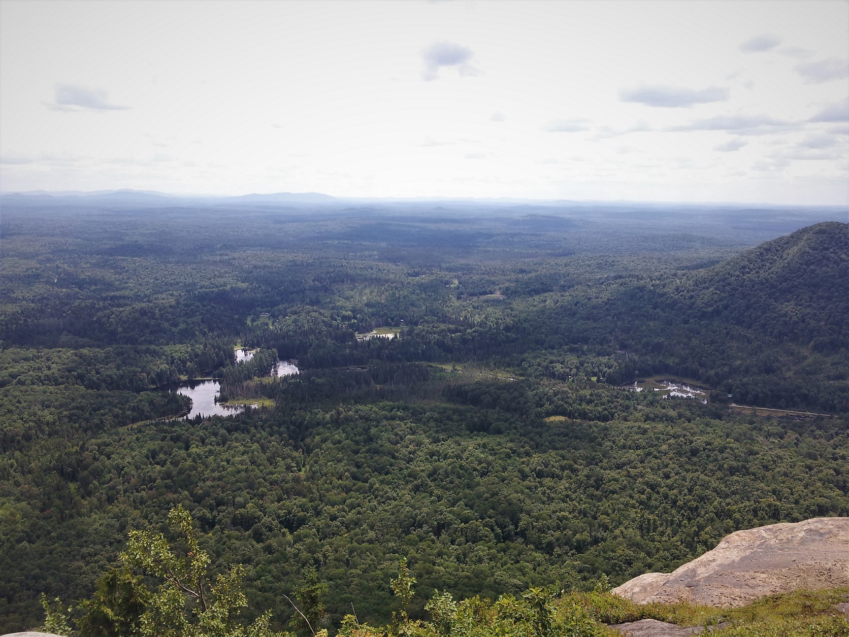
Azure Mountain is located in the township of Waverly in Franklin County and is one of the mountains located in the Adirondacks in New York State. The mountain to though, is not one of the 46 mountains that make up the Adirondack High Peaks. The Adirondack High Peaks were all originally thought to be mountains that were all over 4,000 feet. Today it has been determined that four of the mountain peaks do not actually hit 4,000 feet. Azure Mountain in comparisons is only 2,518 feet tall, so it’s far off from being a high peak. But even though it’s not one of the coveted mountains of the Adirondacks, I still think it is the prettiest. I could be biased though because I’ve been up the mountain so many times.
View from the summit of Azure Mountain during the summer.
While the view from the summit never changes, every new trek adds to my memories of Azure Mountain. The following is a collection of photographs showing the same view from Azure Mountain’s summit just during different times of the year!
View of three neighboring peaks near Azure Mountain; view during the summer; taken 2014.
Another view of the surrounding Adirondacks from the summit of Azure during the summer.
Views from the summit during the summer of 2015.
Those same three summits seen from Azure during the summer of 2015.
I have a thing for these nearby mountains I’ve realized; view from winter 2013.
This is considered a “glacier erratic,” which is basically a fancy term for debris that was left during the last ice age when the ice retreated some 10-12,000 years ago.
I can’t remember how old I was the first time I hiked Azure Mountain (most likely around 3rd grade) but I know my Dad dragged my brother and I up the mountain not too long after we moved to Northern New York from Osceola, NY. We would typically make our annual trek up the mountain in the fall when the Adirondacks are in full color and the mountain top blueberries are ripe enough to eat. Some falls we could determine- based on how many blueberries were left on the summit- that we had beaten the local boy scout troops up the mountain for their annual hike to the summit. On one fall hike, we convinced my mom to join us, another time we brought along some of my cousins Kyle and Derek- Kyle almost killed himself by running down the mountain, and then there was another fall trip up the mountain that I took with the modified and varsity girls soccer teams that we did in lieu of practice on the field.
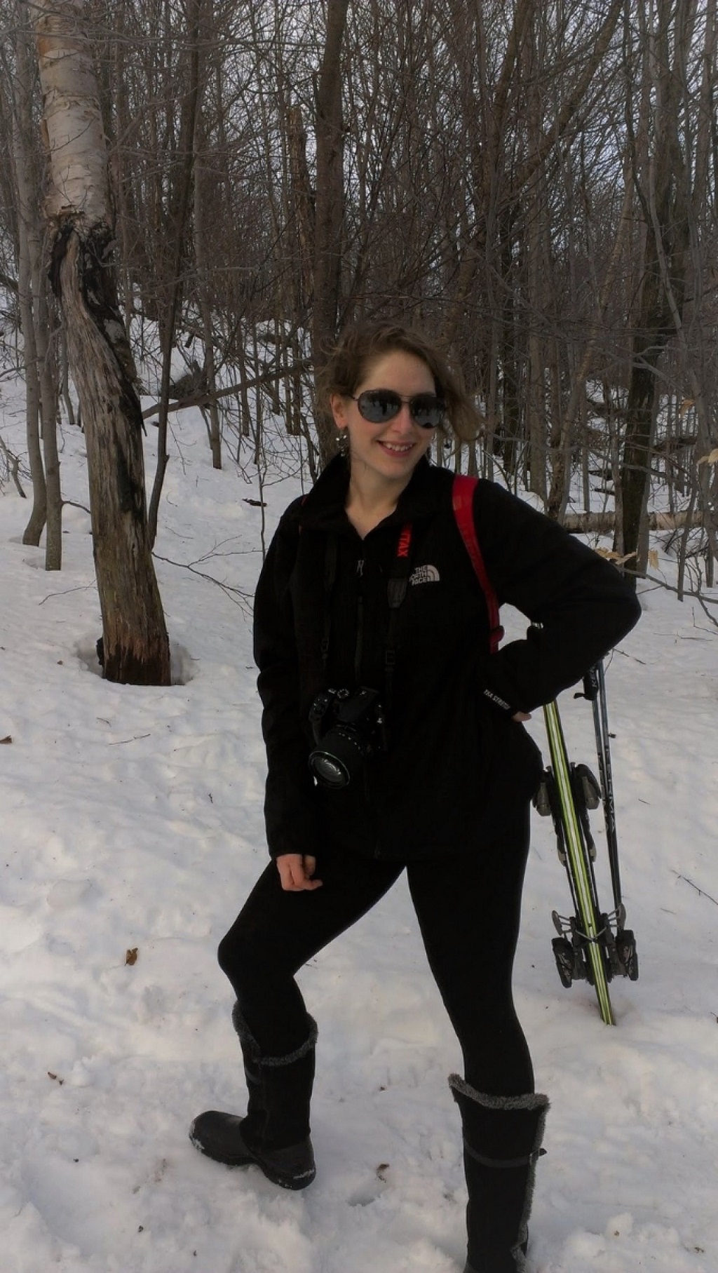
Me during a hike up Azure Mountain in the winter.
When I graduated from high school in 2008, I received a scholarship from the Friends of Azure Mountain. In return for the scholarship, I had to be a Fire Observation Tower “interpreter” on the summit five different days during the summer. Being an “interpreter,” meant hanging out around the fire tower and welcoming visitors to the mountain’s summit, as well as answering any questions that they may have had about the mountain, the Adirondacks, or the fire tower. There were also other things to do other than answer questions, such as documenting the conditions of the trail, picking up any litter seen in the parking lot or on the trail, and even moving stones around the summit to help slow erosion. Was I good at being an interpreter? No, it’s because I was super nervous talking with strangers but I did hang around the tower to be there is people had questions. But I was super good at documenting trail conditions and moving rocks around to areas that needed erosion prevention. I did this adventure five times during the summer of 2008 and I dragged my brother with me every time. Two years later, my brother repaid me by also receiving the same scholarship and dragged me up the mountain a number of times during the summer of 2010. Every time there was a hike, it would be a race to see who could get to the summit first. I think Cody often beat me but there were a few times I made it first.
As you can imagine, I’ve been up the mountain many times, so many that I can visualize most of the winding trail from the parking lot to the summit. The trail starts from the parking lot, which is gravel and located in a stand of coniferous trees. There’s also a sketch outhouse in “front” of the parking in between the trees. At the end of the parking lot headed in the direction of the trail head there is a pile of stones, which super dedicated hikes can pick from and transport rocks to mountain summit. There is a pile at the end of the trail at the summit where the stones can be dropped off at. The stones are used by volunteers to help slow erosion on both the summit and along the trail. There is like a type of warm-up trail that goes from the parking lot to the actual base of the mountain, which is actually an old jeep trail. This trail stays mostly level for its duration and goes through a swampy/marsh area where you can see frogs and then goes into a heavily wooded area. Eventually, you’ll come to a mini wooden sign-in “station,” which is a common sight on trails in the Adirondacks.
The old jeep trail ends in a small clearing where the site of the former fire tower observer’s cabin was once located. The cabin is long gone but there still exists the ruins of a stone fire place indicating that there was once more to the clearing than meets the eye. The cabin went through three different incarnations, the original structure was constructed in 1914, with later reconstructions occurring in 1919 and then in 1936. The cabin would have last been used in an official capacity 1978, the same year the tower was last used to detect fires. Over the years, the cabin fell into disrepair much like the fire tower but wasn’t as lucky- it was officially removed in 1995.[i]
Ruins of the fireplace from the former observer’s cabin.
The hike continues through a forested area on a natural dirt path with some sections slightly altered by volunteers through the addition of stones or logs to help keep the trail intact from erosion. Along the first half of the hike, I have my favorite rocks and trees I like to stop at to catch my breathe. The so called “halfway” mark of the hike is at a rocky outcrop that’s on the right-hand side of the trail as you climb upwards. You won’t miss it. My brother calls it the, “caves.” There are some good rocks to sit on and the cave can be explored to some extent. I don’t think there’s any real caves though, it’s just the way the rock formation has shifted and eroded over the years, which gives the idea of there being caverns.
While it is a great place to stop, eat a quick snack, take a water break, and seems like a “halfway” point of the hike, it’s all a lie. You’re not really half way up the mountain- trust me. I consider the real halfway point to be slightly further up the trail at a ledge with a great view of the surrounding mountains and forest.
This is a view from what I consider the true “mid-point” of the hike, from a walk up the mountain during the fall.
Another view from the “mid-point” stopping point of the hike up Azure.
From that point onward, it’s an even more vertical climb up Azure, kind of like stairs. Eventually, the trail curves to the left and that’s when you know you’re almost at the summit because you can start to see specks of light through the tree canopy. The last 100-200-foot climb is steep but you just have to do it because the summit is close. The trail evens out at the very end through some underbrush and you walk out below the fire tower. To the right of the end of the trail there is a pile of stones where you can drop any stones you carried up the mountain.
One year, the rock pile at the summit was very inspiration.
Which brings me to Azure Mountain’s claim to fame, which is its historic fire observation tower that at one time was part of New York State’s main line of defense against forest fires in the Adirondacks. Before the current fire tower was constructed, there was a fire observation station constructed of wood up on Azure Mountain in 1914. That’s also the same year that the mountain’s name was changed from “Blue” to “Azure.”[ii]
The construction of the fire observation station at Azure followed a common trend in the Adirondack Preserve in the early 20th century- the construction of a number of observation stations on mountain peaks to help combat devastating fires. For example, in 1903 a fire in the Adirondack Forest destroyed 428,180 acres between April 20 to June 8, and only ended because of heavy rains. While in 1908, another fire caused by railroads burned an estimated 368,000 acres of the Adirondacks. In both instances, New York City experiences falling ash and smoke from the Upstate fires. In response, by 1909, a fire detection system was put in place and by 1910, 20 fire observation stations had been built.[iii]
The early fire stations were typically constructed of wood but as anyone can guess, wood doesn’t always stand up well to mountain top weather, lightening, or wind. Many of the early structures didn’t fair well and by 1916, the State had started to replace the wooden stations with steel structures and by 1918, there were a total of 52 steel towers in the State. Also, in 1918 the present galvanized steel tower was constructed on Azure Mountain- materials were transported up the mountain using horses most likely.[iv] Now the exciting thing is that the fire tower is a specific model. The steel frame was manufactured by the AerMotor Company of Chicago and they actually specialized in wind mills. The cool thing is that their wind mill structures could be easily adapted into a fire tower station, instead of the windmill on top, a cabin could replace it. Azure Mountain’s fire tower is the AerMotor Model No. LS-40, which is considered the “heavy construction type.” These models used heavier steel for the tower legs and angled “X” braces, as well as integrated stairs, with a square steel and glass cabin with a hip roof. Because Azure’s tower has five flights of stairs that means it’s 35 feet tall.[v]
This is the only photograph I have ever taken of the Fire Tower on Azure.
A quick search through historic newspapers from 1900 to 1980, found the first mention of Azure in a news article titled, “Commission Designates Game and Forest Protections,” in the Chateauguay Record and Franklin County Democrat on September 11, 1914 where it was reported that, “Harlow Wheeler, formerly forest ranger as observer at the new mountain station on Azure Mountain.”[vi] Now this is interesting information because most sources record that Fred N. Smith was the very first fire observer at Azure Mountain and may have even helped build the original wooden observation station.
An article in the Adirondack News entitled, “Forest Rangers and Mtn. Observers,” reported that Fred Smith was designated Azure Mountain’s observer. The article stated that:
“State conservation commissioner George D. Pratt has announced the appointment of his assistants in the conservation department, including the forest rangers and mountain observers, whose duty it will be to guard the forests of the state throughout the great extent of Adirondack territory from fire also from trespassers.”[vii]
It seems that yearly announcements were made in the local Northern New York newspapers on who had been appointed forest rangers and mountain observers starting in 1914 until the late 1970’s. For example, an April 8, 1948 article reported that Earl Johnson was that year’s Azure Mountain fire tower observer. That year mountain fire observers went back to duty starting April 1 and that a number of observers would be assigned once the weather demanded it. Between Clinton, Essex, and Franklin counties there were a total of 18 mountain stations.[viii]
The Azure Mountain Fire Observation Tower was used as part of the fire detection system in New York for 60 years. The last fire tower observer was Mike Richards, who closed the tower for the season in 1978, the DEC removed the lower sets of stairs to prevent people from climbing up. The use of the towers to detect fires had been slowly replaced with aerial detection flights making the historic observation towers obsolete.
In 2001, the State began to move forward with plans to demolish the fire tower, which was in poor condition to say the least. In response, a group of concerned citizens and organizations like Adirondack Architectural Heritage quickly came together with the purpose of saving the Azure Mountain Fire Observation Tower by working with the DEC. The DEC gave those concerned with saving the tower, the opportunity to form an official group who would be involved in the maintenance efforts of the tower for long term. The group that formed was the Friends of Azure Mountain and was created largely in part to the efforts of Carolyn Kaczka and Michael McLean.[ix]
In the same year, as part of the effort to save the Azure Mountain Fire Observation Tower, it was listed on both the State and National Register of Historic Places as part of a multiple property nomination, Fire Observation Stations of the NYS Forest Preserve. Other fire towers included in the nomination consist of the towers on Arab, Blue, Hadley, Kane, Snowy, and Poke-O-Moonshine Mountains. Azure Mountain is listed under Criteria A and C because of its historic significance to NY State’s forest preserve (Criteria A) and because architecturally it is a good representative of early 20th century fire towers (Criteria C).[x]
By 2002, the involvement of a number of forest rangers helped the cause. Jeff Balerno was able to coordinate seven helicopter flights to Azure’s summit to drop off needed construction materials that would be used in restoring the tower. During the 2002 summer, a collection of people including forest rangers, Americorp volunteers, members of the Friends of Azure Mountain and volunteers worked to replace damaged and rotted wood, hardware, repainted metal, etc. basically everything you see today on the tower was done during the 2002 restoration. Eventually, a DEC structural engineer inspected the newly restored Azure Mountain Fire Observation Tower and on September 27, 2003, the tower was once again open and could be used by the public![xi]
View from the fire tower’s cabin and those three mountains again!
This is a close-up of the map that is located at the top of the fire tower. You can see the names of the three neighboring mountains, I’ve photographed constantly.
The interesting thing is that Carolyn Kaczka trained me on how to be a fire observation tower interpreter for my internship/scholarship in 2008. ON the first day that I was the interpreter for the summer. I don’t think I saw again for a very long time. After moving back home from graduating UVM, I did occasion consultant jobs, one of which was conducting a free walking tour of downtown Potsdam, NY, which is known for its Red Sandstone buildings. I did this as part of Adirondack Architectural Heritage’s yearly tour offerings in May 2016. At the end of the tour, this woman came up to me and re-introduced herself as Carolyn and that she had enjoyed the tour! I can’t remember how the full conversation went but I do remember telling her that after graduating from SUNY Potsdam, I went on to grad school for historic preservation and was doing the occasional odd consultant job. It was a wonderful surprise to see her again and, in a way, see how somethings in life are connected. I’m not sure if being having a scholarship/internship with the Friends of Azure Mountain is what exactly got me into historic preservation but maybe subconsciously, it was there the entire time when I was making decisions about grad school.
On that note, Friends of Azure Mountain is always looking for volunteers, as is most non-profit organizations. If you live in the area of Azure or any historic fire tower for that matter, and enjoy hiking and helping preserve history and trails for others to use…. I suggest volunteering or at least contacting them to see in what ways you can help.
I have some big news to share on the blog, today I’m not going to focus on a recent history adventure but instead giving an update on both my blog and life.
If you’ve been following me around recently, you will know that I’ve been temporarily living in California on deployment with FEMA since June 2017. As a reservist with FEMA you’re basically called to go to work in the wake of a disaster. So I originally came to California last June during the response efforts for state wide flooding. Since I’ve been here, California has had other disasters such as a number of large devastating fires in both the north and south of the state, and even mud slides. It’s been a learning experience since this was my first deployment with FEMA and my first excursion on the West Coast. Since I’ve been here I’ve seen a lot of awesome things when I’ve had time to travel.
Well late last year some permanent positions with FEMA’s Region IX office opened up and I applied to see what would happen. Long story short, I was hired for a position in Sacramento, so I’ve officially become a resident of sunny California!
View of downtown Sacramento, hence the “Love Sacramento” graffiti.
I’ve been back in California permanently since May 2018 and it has been a lot take in for the time being since my entire life has been spent on the East Coast and that’s where all of my immediate family and closest friends reside. But at the same time it has been exciting because its all so new- living on the West Coast, and having a full time job doing what I like to do and went to school for.
When I first graduated from UVM (University of Vermont) in December of 2013, when I was 23, I barely had any idea of what the hell I was going to do or how I was going to get a job “doing” historic preservation. I had been involved in a volunteer preservation group created from a class project and was trying to get more involved in Preservation Burlington but it wasn’t enough to get good enough experience to get a job in the field. When I finally moved home about a year later, I was super broke and honestly pissed. I assume a lot of people know that feeling of both anxiety and anger of not being able to get a job doing what you love to do or even makes you happy. When I moved home, I volunteered at the local museum, which I had experience working at before but it didn’t seem like that would help achieve the experience I wanted.
The biggest step in the right direction that I directly link to where I am today, is the Director of the Potsdam Planning Department looking at my resume and suggesting to the Village of Potsdam’s Board of Directors that they should hire me to write a National Register nomination for the Potsdam CivicCenter. I got the consulting job by actually creating a proposal for the job and I remember emailing my former UVM professors, Bob and Tom, to ask questions on how to write a proposal and more importantly how to create a cost estimate for my work. Trying to “guess-ti-mate” how much you’re worth isn’t easy or fun and one too many times I’ve been told I’m selling myself short. On that note, if you’re trying to work as a historic preservation consultant, please feel free to reach out to me if you have questions. I might not have all of the answers but I can at least listen and give suggestions from my own experiences!
The consultant jobs I’ve had since that first National Register nomination, while few and far between, are all part of the reason I was hired by FEMA to begin with. But I would also say that maintaining this history-preservation-adventure blog has created “work” for myself and has served a number of purposes. It’s not only been an outlet for showcasing by mad researcher skillz and mediocre writing abilities but also has allowed me to educate the public on historic preservation things. If I remember correctly, in my original interview with FEMA I referenced this blog and the work I put into researching and writing posts for non-preservationists to read and learn about the history and preservation around them.
So, as a quick aside- A Big Thank You to everyone who’s ever read a post, liked a post, shared a post, or even commented on a post. Thank you so much! I honestly hope you enjoy reading my quirky posts and that maybe for other young preservationists out there, you get inspired to start your own blog or create your own “work” to gain the experience you need in preservation. And if you’re super interested in working with FEMA, FEMA’s Environmental and Historic Preservation cadre is always hiring- maybe you’ll find your calling with FEMA too! This is in no way, shape, or form sponsored by FEMA. I just know being hired as a historic preservation specialist reservist, was super exciting and my first “real” job as a historic preservationist, that wasn’t a consulting job.
So what does this big change mean for the blog, since it was started as a Northern New York history adventure blog. Well it means that more of my posts will be West Coast-centric but I still have a lot of posts on Northern New York topics that I want to write about and share with people. I think my “What Is This Jargon!?!” series will be a great way to showcase both architectural jargon and related photographs from both sides of the county. I also think there’s a lot to obviously share from here in California since the architecture and history out here is very different from Northern New York and even the East Coast in general, which is all stuff that you might not be familiar with.
So as not to let this be a post with just a bunch of words, here’s some photographs for planned upcoming posts on both West Coast and East Coast topics:
Ruins of the fireplace from the former observer’s cabin.
This post took me a little longer than expected to finish up because I have a ton of photographs for Fort Ross. I hope you enjoy them all!
The main route from Point Reyes to Fort Ross is Route 1, which winds dangerously along the coast. Some “shoulders” of the roadway are literally the coastline with the Pacific Ocean with its waves crashing below the cliffs. There are many spots and turn-offs along the road to stop and take photographs, as you can imagine.
Google Maps oddly enough, directed me off of Route 1 and into the mountains and cow pastures along the coast. Eventually, I found myself on a single dirt lane road in the middle of the woods in my Kia Soul rental. I assumed immediately that Google Maps was off its rocker and had gotten me lost, which wouldn’t have been the first time. As I was driving along the dirt road, I figured it had to be an old logging road in the woods and since there were no easy ways to turn around, I decided to keep going because there had to be an end to the road. My favorite part of the dirt road detour was when Google Maps announced that I had arrived at my destination. I had in fact, not arrived at my preferred destination of Fort Ross but was still in the woods.
It would seem that Google Maps had chosen a path less traveled by for me to adventure down. The single lane dirt road ends right across the street from the main entrance of Fort Ross; the dirt road is actually a path that goes by the old Russian orchards that are also part of the Fort. On that note, for those also adventuring along Route 1 to Fort Ross….trust me, just stay on Route 1, you’re drive right by Fort Ross. You won’t miss it.
Fort Ross is for the most part a reconstruction that has been beautifully done and is as historically accurate as possible. Even though it is greatly reconstructed, the Fort has a very interesting history and if I was to do a full run through of the land and it’s history, this was would become a book. So instead I’m going to focus on four different aspects of Fort Ross’ history: the Kashaya Tribe, the Russians, the Call Family, and the preservation efforts of the Fort.
The Kashaya:
Before the Russians began to settle the area that would eventually became Fort Ross, the first people known to live there were the Kashaya- they still live in the region today. The Tribe consider their name to be “People From the Top of the Land,” while the name “Kashaya,” meaning “expert gamblers” was given to them by a neighboring Pomo group. Originally, the Kashaya made the lands surrounding today’s Fort Ross, their home; roughly a range of 30 miles inland from the coast and 30 miles North-South from Gualala River to Duncan’s Point (South of the Russian River). An important village site of Mitini, which was near Fort Ross was important to the Kashaya territory, since it was the site of an assembly house where people would gather for ceremonial and social events.
In comparison to the other California Indians, the Kashaya experiences less acculturation and fewer forced removals to missions and reservations but that doesn’t mean it didn’t happen. When the Kashaya first encountered the Russians in 1812, the two groups came to an agreement over the use of a parcel of land, which was to become Fort Ross. The agreement was in accordance to a Russian policy that had been created to seek cooperation with local inhabitants that had previously been established in Siberia and Alaska. Fort Ross in a short time became a “tri-cultural community” of Russians, the Kashaya, and Aleut hunters where elements of culture and languages came together. Based on historic Fort records it also seems that the Coast Miwok Indians from Bodega Bay had a presence at the Fort as well.
After the Russians left, obvious changes occurred to the Kashaya’s way of life. Access to their traditional resources areas became more difficult because much of the land had become private property. Luckily, relationships with the Kashaya and new settlers near Fort Ross were better than in other parts of California and the country. By the 1870’s, the Kashaya were living in two villages located on property owned by Charles Haupt, a rancher who had married a Kashaya woman. The property was about 5 miles inland from Stewart’s Point, while a third, smaller village had been established near Stewart’s Point. In 1914, the federal government at the behest of Charles Haupt Jr. started the process to purchase a 40 mile acre tract of land four miles inland from Stewart’s Point, as a permanent location for the Kashaya; the location was not the best given that it is on an exposed ridge with poor soils and little water.
The reservation still exists today but the story doesn’t stop there, in 2015 after five years of fundraising through a group effort including the Kashia Pomo (another spelling of Kashaya), The Trust for Public Lands, Sonoma County, as well as other private foundations and groups were able purchase nearly 700 acres of ancestral lands of the Kashaya along Stewart’s Point. In exchange for the land, the Kashia agreed to build a public bluff-top trail along the coastline. The purchase enlarged their small reservation but about 18 times the size it originally was from the 1914 land purchase by Charles Haupt Jr.
The Russians:
Throughout the 1600’s the Russians had begun to move east across Siberia and the Pacific Ocean into Alaska. They set up posts in the Alaskan frontier and began working with Native Alaskan tribes to hunt for furs. From there, the Russians moved south, eventually pushing into California at the beginning of the 1800’s. In 1812, a team of 25 Russians and 80 Native Alaskans arrived in California with a number of goals, which included: establishing both a fort and a colony to grow crops (like wheat) that could be shipped back to Russian settlements in Alaska; hunt marine animals such as otter because the need was great for furs; and to trade with Spain. Spain’s colonies were located across Southern California and would have been a great opportunity for Russia to expand their holdings through trade. Another way to think about all of that, is that this is 1812, and Russia is entering the colony game really late in comparison to Spain, England, France, and now the newly established United States of America. In comparison the French, English, and Spanish already had established colonies as early as 15th century when Columbus, sailing for Spain, first landed in what is known today as South America. Along those lines throughout the 17th and into the 18th centuries France had a steady claim on the fur trade in North America along the St. Lawrence River.
Historic Images of Fort Ross from the museum on site.
Artifacts from the Chapel, as well as a photograph of the Chapel.
The Fort the Russians established was named, “Ross” as a play on words and their mother county, since imperial Russia was known as “Rossia.” Their plans of having a successful establishment never fully came to realization- the climate along the coast was not suited for growing the needed crops; from over hunting, the population of otters drastically declined; and the anticipated trading with Spain never occurred. By 1841, the Russian-American Company was looking to sell their holdings and get the hell out of America, which leads us to the Call Family.
Fort Ross, as I’ve mentioned consists of many replica buildings save for a couple of buildings. With that said, the buildings are authentic to Russian construction methods and exhibits within the buildings give an idea of what life would have been like during its Russian era.
Buildings at Fort Ross:
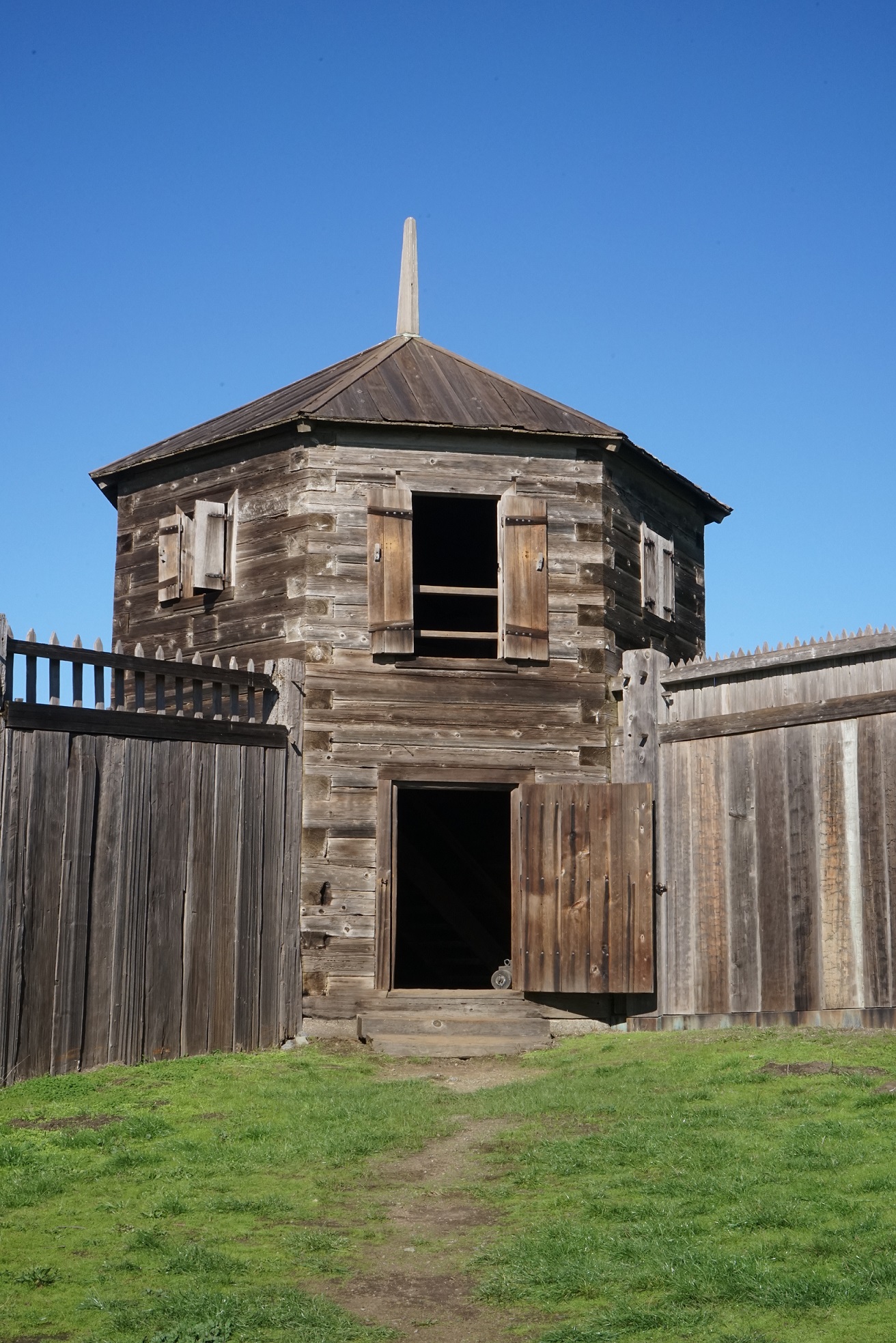
The Rotchev House
The Rotchev House is the only surviving building from the Russian Fort. It was renovated in 1836 for Alexander Rotchev, the last manager of the fort, for him and his family. Eventually, the Call family would live in this house before building their own.
Warehouse
The Kuskov House
The Kuskov House was the house used by the first manager of Fort Ross, Ivan Kuskov. The replica was completed in 1983 and on the first floor it has storerooms and an armory, while the second floor has living quarters.
The Official’s Quarters
The Official’s Quarters was reconstructed in 1981 and consists of a dining area, sleeping rooms, storage areas, and various other rooms.
Blockhouses
The Northwest Blockhouse was reconstructed in the 1950’s.
View from the blockhouse, looking towards the Kuskov House and Chapel.
View from the Southwest Blockhouse towards the ocean and the cove where Russian ships would have been.
The Chapel
The Chapel was destroyed during the 1906 Earthquake and then rebuilt in 1916. The building received a new foundation, walls, and bringing the roof into the right position. In 1955, the Chapel was restored again to make the building closer to its original appearance. In 1960, the cupola was replaced with a more authentic Russian Roof. Sadly, in 1970, a fire completely destroyed the Chapel but it was rebuilt in 1973.
The Call Family:
After the Russians sold their Fort and associated land, the property changed hands a number of times and was used primarily for ranches. The family was care about this post, is the Call family who owned a portion of the original property including the Fort. In 1873, George W. Call purchased 2,500 acres and the Fort property with all of its buildings, eventuality he would go on to acquire a total of 7,000 acres and create a business enterprise with components in agriculture, livestock, and shipping. Under his ownership the property became a community center and a shipping port, which included a post office, store, saloon, hotel, wharf, warehouse, and even a school house.
Prior to purchasing the land, George W. Call had made a fortune in Chile and when he moved to the Fort Ross property he brought his wife, Mercedes Leiva, who is consistently called a beautiful Chilean woman and their four young children. When they Calls moved to their new property, they first lived at the Rotchev House. By 1878, there were a total of 8 Call children (five girls and three boys), which made George build a new house.
The Call Family House is still a part of the Fort Ross State Park site and the building is open for docent led tours the first weekend of each month. That was the main reason for when I visited the Fort when I went. The docent led tour was very informative about the Call Family. The coolest thing about the house is that it was is still very much the homestead of the Call Family; the last Call children passed away in 1976 but descendants of George and Mercedes’ children still live in the area. One of the family’s direct descendants was actually at the house the day I went and he was answering questions for visitors. The family still occasionally has reunions at the home from what my docent said. Another fun tidbit that my docent shared was that the Call family were, “pack rats,” meaning they kept everything and for that reason everything on display in the home was originally was owned by the Calls, which makes for a very real interpretation of the family’s home and the family’s life at Fort Ross. The other cool thing about the home is that parts of the Call House were originally parts of the Fort.
Time Line for Preservation Efforts of Fort Ross:
Fort Ross has a long history of historic preservation started in a way by George W. Call himself. During his family’s ownership of the property, the Rotchev House was maintained, first as the home of the Calls and then as the Fort Ross Hotel. At the same time, the Russian Official’s Quarters were renovated to be a saloon. The family also preserved the Chapel and used it for a number of things including a horse barn and for the occasional wedding.
1891- Interest in Fort Ross for its cultural and historical important as a sacred place for Russians, resulted in many pilgrimages to the site. One such pilgrim was Bishop Vladimir, who made a proposal to George Call to buy the Chapel and cemetery to save them from further deterioration. The purchase never happened, but Call did start putting a thought into preserving the site.
1897– Another Bishop from Russia pilgrimaged to the site- Bishop Nikolai who also attempted to obtain the Chapel and cemetery from Call. Again, nothing came from the talks but in September of that year, Call donated lumber to restore the Chapel for the use as a Sunday school.
1902– The California Historical Landmarks League is incorporated.
1903– William Randolph Hearst sponsors a Citizen’s Campaign to raise money to save several historic landmarks, including Fort Ross. The stockage portion of Call’s property is purchased with funds raised.
1906– Fort Ross becomes an official historic site; less than a month later, the San Francisco Earthquake damaged a number of the historic buildings at Fort Ross.
1916- Funding is made available to begin repairing the damaged buildings at Fort Ross. The organization, Native Sons and Native Daughters of the Golden West take special interest in the Chapel and use the area as a place to celebrate the July 4th for a number of years.
1925- The Russian Orthodox Congregation of Holy Trinity Cathedral in San Francisco are invited to a July 4th celebration by the Native Sons and Daughters; the Congregation still continues an annual July 4th pilgrimage to this day.
1928- Fort Ross becomes one of five historical monuments in the new California state parks system.
1936- A group from the San Francisco Russian community begin the initiative group for the memorialization of Fort Ross and begin publishing articles in Russian newspapers about the property’s history. The new year, the group creates the Russian Historical Society in America.
1945- The Society locates the lost bell of Fort Ross- it was at the Petaluma Adobe. The Society, along with the Native Sons and Daughters bring the bell back to the chapel in a special Labor Day celebration.
The original bell was destroyed in the 1970’s.
The current bell was recreated using materials from the original bell and a rubbing that had been made from the original.
1961- Fort Ross is designated a National Historic Landmark.
1962- Fort Ross becomes a State Historic Park after the State purchases 353 acres from the Call Family.
1966- Fort Ross is nominated to the National Register of Historic Places.
1970- The Rotchev House is nominated to the National Register of Historic Places. That same year, fire destroys the Chapel and the historic bell, less than a year later an arsonist sets fire to the Rotchev House, which luckily only burned the roof and attic.
1972- A new water supply system is built and plans are carried out to reroute Highway 1 (it had originally divided the stockage of the Fort). Federal money is available to restore the sites in the state. Various organizations come together to get funding for the “Restore Fort Ross Fund.” Key groups include the local Sea Ranch residents and several Russian-American groups. That same year, state parks director, William Penn Mott Jr. develops the first Citizens Advisory Committee for Fort Ross, which includes local residents, Russian Americans, and the Kashaya Pomo.
1976- The last of George and Mercedes Call’s children pass away.
1985- Ribbon cutting ceremony for the new Fort Ross Visitors Center
1990- The Citizens Advisory Committee is dissolved. The Fort Ross Interpretive Association continues the work the Committee had started.
2010- Fort Ross almost closes because of the state budget crises. Viktor Vekselberg, president of the Russian business group, Renova Group, meets with then Governor Arnold Schwarzengger to discuss plans to keep the Fort open, and creates the Renova Fort Ross Foundation to help with funding.
2012- Fort Ross celebrates its bicentennial!
This is all a very small snippet of the history of Fort Ross. There’s a lot more I could have went into detail on such as the Native Alaskans who came here with the Russians of the other ranchers who owned the Fort Ross property after the Russians sold the land. Visiting Fort Ross was super exciting and there wasn’t a lot of people there when I visited, so it was nice to be in the building by myself for the most part.
Views of the ocean from Fort Ross and the Call Family House
From left to right: the Officials’ Quarters, the Rotchev House, Warehouse, the Northwest Blockhouse, and the Kuskov House.
There’s a lot more to learn about, so please check out some of the resources listed below for more information on this really amazing place.
As always thank you for reading!
Further Information and Resources:
Most of my information on Fort Ross comes from the following book I purchased during my visit:
Kalani, Lyn, Lynn Rudy, and John Sperry, ed. Fort Ross. Fort Ross Interpretive Association, 1998.
Sections that were relevant to my post include:
Parrish, Otis, “The First People,”pgs. 6-7.
Watrous, Stephen, “Fort Ross: The Russian Colony in California,” pg. 11.
“The Ranchers,” pgs.24-25
Sakovich, Maria, “Partners in Preservation,” pgs. 27-28.
“The Fort: Structural History and Reconstruction,” pgs. 29-38.
I meant to get this post out sooner than what I did. Work had been much busier than expected since returning to California in January. So free time after work was limited but I still have been going to the Sunday “Shut Up and Write” sessions. For the time being though I’m currently on a much needed vacation home in Northern New York. So while I’m home, I hope to catch up on a number of posts I’ve written but haven’t yet shared on the blog.
Anyways, the next part of my adventure along California’s coast was in Point Reyes National Seashore where I stayed at a hostel located within the National Park and hiked a couple of shorter trails: the San Andres Fault Loop and part of the Coastal Trail.
The Point Reyes National Seashore was established in 1962 by Congress and is located on the Point Reyes Peninsula. The Peninsula is separated from mainland California by a linear valley, which happens to be on the San Andres Fault. The Fault is where the Pacific and North American Continental Plates meet; geology talk time- this means that the Pacific Plate is slowly sliding underneath the North American Continental Plate and when things don’t go smoothly with this geological process, earthquakes happen. Today about 1/3 of the National Seashore is a protected wilderness, while another third is preserved as a pastoral zone for dairy and beef farms that date back to the 1880’s. The National Seashore also offers numerous outdoor activities and places to see for visitors; there’s roughly 150 miles of trails within the boundaries of the Seashore.
The drive from Sacramento to Point Reyes is roughly two hours. Inverness, which is the place I wrote about in the last post, is about a 15 minute drive from the National Seashore’s main entrance….longer if you’re planning on driving deeper in the Seashore. The car ride is very simple. The route goes through Point Reyes Station- a quaint looking town but I didn’t stop. I drove to the Point Reyes Visitor Center to get a map and to buy some souvenirs. I did walk on a short trail located near the visitor center: the San Andres Fault Loop (roughly 0.6 miles long). The trail is along a mostly even terrain that winds through a field and a forested area, which must be a popular hangout for the local deer population.
The local welcoming committee to the Point Reyes National Seashore
Along the trail there are a number of signs giving both geological history of the region and the history of the Great 1906 Earthquake. By the way, it seems any time I go to something related in anyway to history here in California there’s always some connection to the 1906 Earthquake or the Gold Rush….there always is a connection….no matter what.
View of the trail of the San Andres Fault Loop.
The fence was split in two when the 1906 earthquake hit. The blue markers also indicate the active fault line.
Within the National Seashore, I stayed at the Point Reyes Hostel located in the heart of the Seashore. It’s very secluded yet homey with a large kitchen, porch area and a cozy living room. The hostel is at the site of the historic ranch, Rancho de Laguna, which was established at the current site in 1866. Eventually, the ranch buildings were purchased by the Park Service in 1971 and instead of demolishing the buildings, they were renovated and the hostel was opened up in 1972.
Decor outside of the hostel.
The ladies eight bed dormitory was spacious, as was the shared bathroom within the main hostel house. There’s also a number of newer looking buildings that are apparently more dorm rooms for larger groups aiming to stay within the Seashore. When I’m traveling around I like to stay at hostels because it’s way cheaper and it gives the opportunity to meet cool people. While at the Point Reyes Hostel I didn’t really talk to anyone like I had at previous hostel stays in San Francisco and San Luis Obispo. Since the Point Reyes Hostel is secluded and in a forest, there is no Wi-fi and there’s definitely no cell service. I was able to get one bar at the end of the road on both of my cellphones (work phone is AT&T and my personal cell is Straight Talk in case you’re interested). I spent the night at the hostel writing…you guessed it…blog posts and reading on my tablet, A Company of Liars by Karen Maitland is what I had been reading at the time. Side note- it’s a very interesting book but literally the last chapter isn’t the best. I looked up the book after finishing to see if others were as annoyed as I was and it seems like the general consensus was that the ending isn’t the best. So readers beware.
In the morning, I decided to hike the Coastal Trail, which the trail head is just down the road from the hostel. The morning was colder than I expected- probably in the 40’s. I didn’t see a lot of wildlife on the trail other than groups of partridges. On that note, I’ve never seen groups of partridges- they’re funny little posse and they all flap off together when you get too close. Closer towards the coast and the beach, you could hear the crash of the ocean waves.
There were no other people on the trail, which can kind of be unnerving in a large national forest especially since there’s signs telling you to watch out for mountain lions, not to hike alone, and to flee to higher ground in the case of an earthquake/tsunami death combo. On another side note, what the wrong with California?!?!?!?!?! We don’t have these kind of warnings at the beginning of trail heads in New York. This all just continues to solidify my thoughts that California is a hostel environment….
Now back to the coastal trail….
When I emerged from a marshy area with a lot of tree coverage, there were sloping hills where grazing elk could be seen. Let’s be honest, they probably saw me first and were probably wondering what the hell I was and why I was up so early. I assume I must have been a spectacle for the elk to watch since I was flaying my arms around trying to determine if my phones were going to pick up a signal or not.
The trail curved through the hills without any real incline. To be honest most of the trail seemed to be an even grade without any real noticeable inclines/ downhill sections and then finally the path emerged onto rolling hills towards the beach.
There was, unsurprisingly, no one at the beach. So I was able to hang out on the beach by myself and take lots of photographs. Based on the trail signs, the Coastal Trail continues past the first beach stop to another beach area. Instead of continuing on the trail, I decided to head back to the hostel to get ready to leave for the day to travel the rest of the way to Fort Ross, which would be another 1 ½ drive up the coast.
On the walk back through the woods, I was still keeping an eyes and ears alert for any unusual rustling sounds. Call me a Nervous Nancy but there’s a crazy need to be alert in the California woods especially when most trail head signs warn of tsunamis and mountain lions. It also didn’t help that the local, patrolling, partridge posses are noisy in the wee hours of the morning. So while I was walking along the trail observing my surroundings, minding my own business, I looked down the trail and saw that it was clear, I looked down at my feet and then I looked back up and saw some four-legged canine creature ahead of me on the trail.
Well let me tell you. I freaked out. I think it was a coyote.
It looked at me.
I looked at it.
I mentally freaked out.
It remained calm.
I yelled a little to scare it off.
It stayed on the trail staring at me- probably wondering what the hell was happening.
Actually, wait. It was probably judging me for hiking alone on the trail in the early hours of the morning. Obviously that’s what it was doing- judging the lone human in the woods.
I decided my best move in our standoff was to walk towards the coyote while making some obnoxious noises. It must have been my menacing look and walk that caused the coyote to saunter off the trail….LOL. Who are we kidding, probably not. But at that moment I realized that I probably needed an adult supervising my outdoor adventures, especially in California. For the rest of the walk back to the hostel, I only saw a few cute bunnies and luckily no more sightings of larger mammals.
And that was my adventure in Point Reyes National Seashore.
Thanks for reading! Next up, Fort Ross.
*See below for applications to be a “supervising adult for Courtney’s Adventures.”*
Further Information:
All of the information about Point Reyes came from a pamphlet I picked up at the Point Reyes National Seashore Museum but more information about the National Seashore can be found here:
*Sadly, there’s no actual applications to be a supervising adult in my adventures, I just need to be better prepared for the unexpected. Obviously, my years as a girl scout didn’t prepare me for coyotes in the woods at 8 am. But if you’ve had moments in your own adventures, where you questioned your life choices, please feel free to share!
This week is going to focus on a weekend trip I took out to Marin County to see the central coast area of California, especially around Point Reyes National Seashore and up to Fort Ross, a historical site with a reconstruction of the original Fort that was used by the Russian’s from 1812-1840’s. The main reason for the trip was to see Fort Ross but I also stopped along the way in Inverness and Point Reyes.
While in Point Reyes National Seashore, I visited Inverness, California to get dinner. Inverness is located on the west shore of Tomales Bay and is surrounded by the National Seashore. Fun fact about the town, parts of two John Carpenter’s films, The Fog and The Village of the Damned, were shot in and around the community. I only stopped in the town briefly to get dinner at the Saltwater Oyster House but while there I discovered a place that’s part of the Atlas Obscura atlas, the “Tomales Bay Shipwreck,” also known as the S. S. Point Reyes, which is an apparent nod to the S. S. Minnow from Gilligan’s Island. The shipwreck is not really a “shipwreck” but more of a fishing boat that has been grounded in the restored wetlands of Tomales Bay. A previous owner had made plans to restore the boat but these were never acted upon. Instead the boat has become an added tourist attraction and photography spot for the National Seashore and the Giacomini Wetland Restoration Project.
The S. S. Point Reyes is located in the Giacomini Wetlands, right behind the Inverness store. At one point there boat was almost removed because of the restoration work to the native landscape but the photography community rallied around the boat and it has remained in its place. In 2016, the haul of the ship was burned pretty bad by either vandals or photographer’s who screwed up during their photo shoot; a full investigation was never conducted on the fire.
The other cool part of the boat’s location is the Giacomini Wetlands themselves. The Waldo Giacomini Ranch Wetlands Restoration Project, other than being a mouthful, is the attempt of the National Park Service to restore the former dairy ranch back into the tidal wetlands and floodplains the area is meant to be. The project’s roots stem from the 1972 statewide Coastal Act, which places a high value on protecting California’s natural resources. The act was directly related to a failed 1968 plan to extensively develop West Marin. The ranch lands were eventually incorporated into the Boundaries of the Golden Gate National Recreation Area, so that the Park Service could purchase the land to do the work. In 2000, the purchase was finally completed and within 7 years the wetlands restoration work done. The project has resulted in 550 acres (roughly 50% of Tomales Bay’s wetlands) to be restored to their native habitat. In comparison though, the 550 acres is the estimated equivalent to just 12% of the total lost coastal wetlands in Central California. The restored wetlands are home to a number of animals including: salmon, seals, bat rays, white pelican, black-bellied plovers, white tailed kits, river otters, raccoon, and even bob cats.
Across the street from the Inverness Store, is the post office and the Saltwater Oyster House, an upscale yet laid back restaurant that’s open for lunch and dinner. I went during their dinner service and was lucky enough to get a seat at the bar during the busy dinner service. My bartender, who happened to be the owner was great and attentive. I went with the Oyster Stew, which was cream based with chunks of oysters, leeks, and brioche croutons. It was very good, not too salty and the leeks went well with the oysters. I know, you’re probably wondering why I didn’t get any raw oysters. It’s because I’ve never had them before and felt a little out of my element trying to order them. But seated at the bar I did get a great view of the man preparing the oysters for those who ordered them. It was hypnotizing to watch him shucking oysters and plate them on a bed of ice. I did order dessert though, the chocolate brownies sundae, to be exact. I was expecting something small and delicate and instead got enough sundae to share! Atop of the very dense brownie was frio gelato and that was covered in a creamy chocolate sauce that also hardened into a shell on the gelato. I just want to let you all know, that I took one for the history adventure team and ate most of the dessert.
I had no regrets.
It was glorious.
I would highly suggest visiting Inverness and especially the Saltwater Oyster Bar to anyone. I definitely plan on visiting the area again and would to go there for food again. It might be fun to go during the lunch services to see how different the menu is and if it is as busy as dinner had been. I would love to go back and explore the small town of Inverness now that I know it was used in a few films. It would be fun to compare scenes to what is there now much like I’ve done with historic postcards in the past.
Watch for my next post on Point Reyes National Seashore and my brief time there!